2015
Published:

Published:
Published:
Published:
Published:
Published:
Published:
Published:
Published:
Published:
Detecting fire occurence in Southeast Asia using satellite remote sensing and machine learning 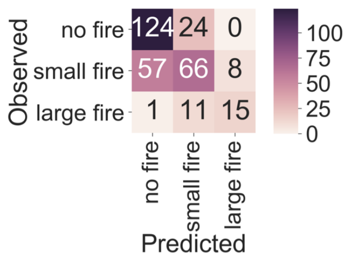
Published:
Make images and figures colorblind friendly by swapping their colormaps 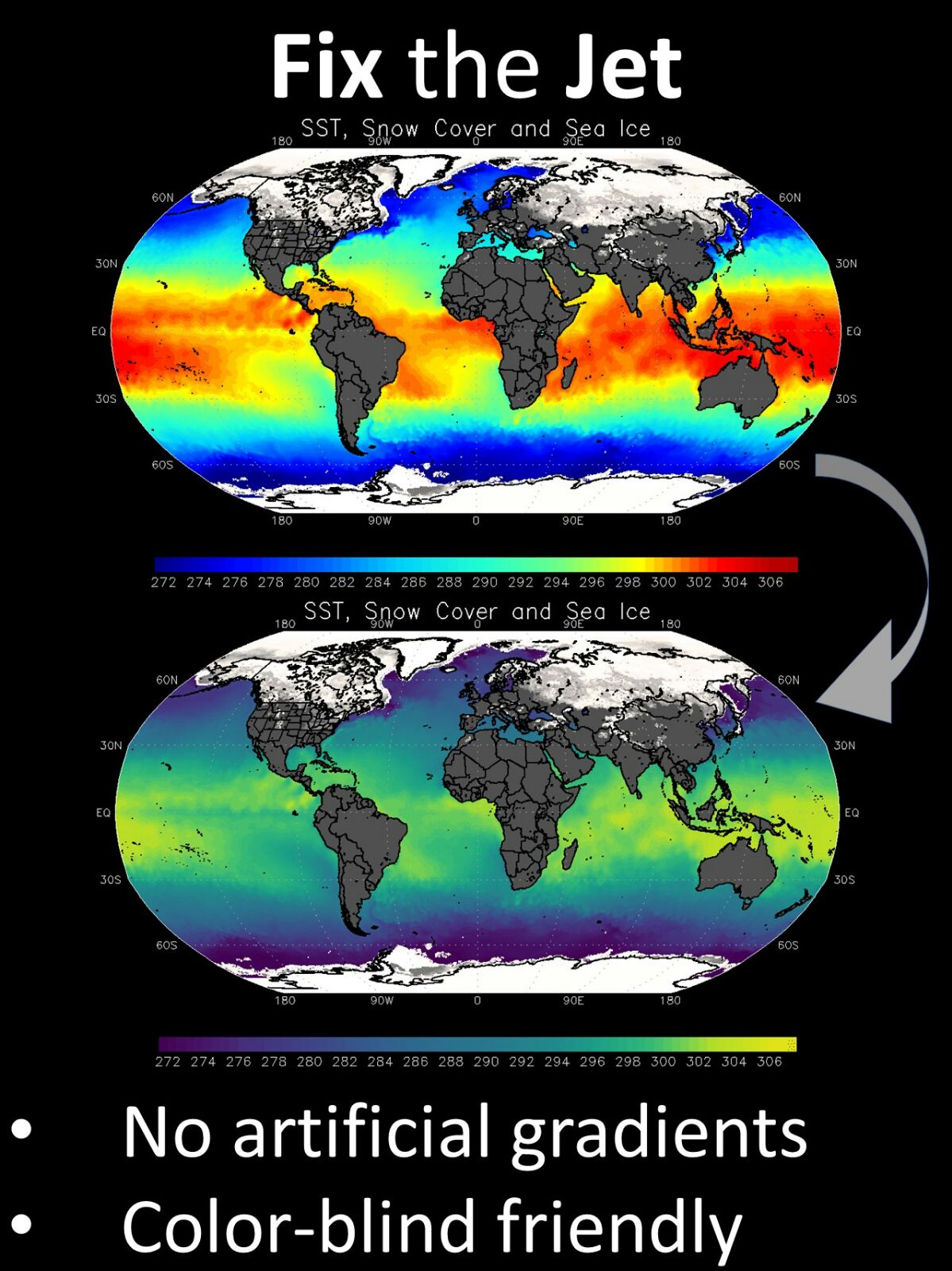
Published:
Live season detector using a network of cameras across North America 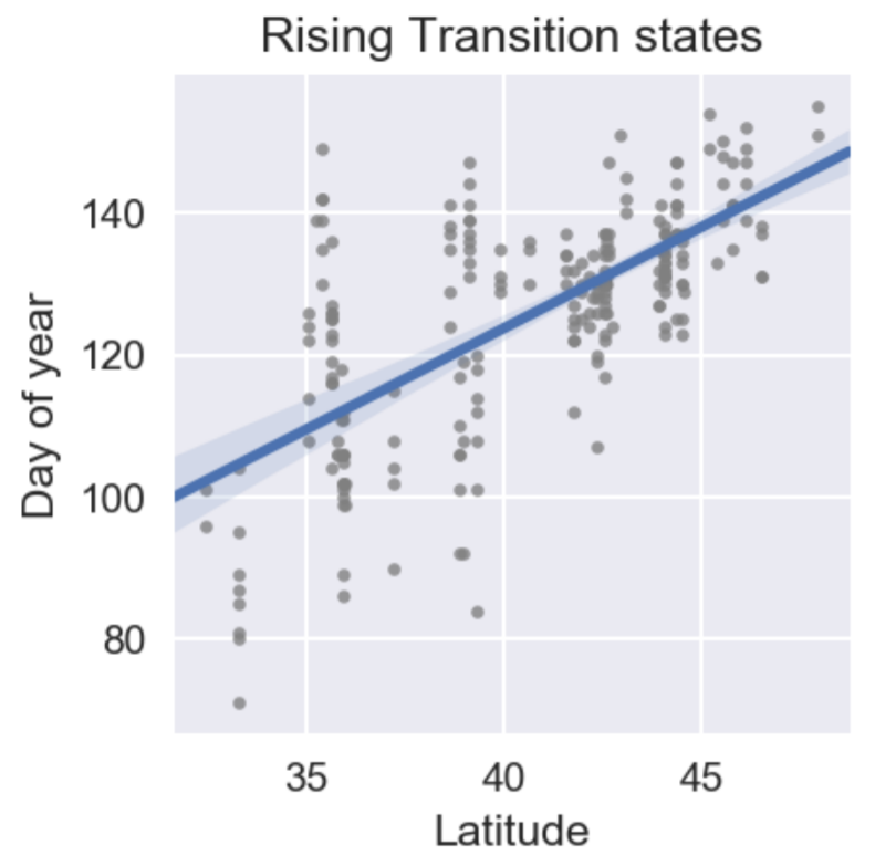
Published:
Near-realtime global flood mapper using automated, localized change-detection 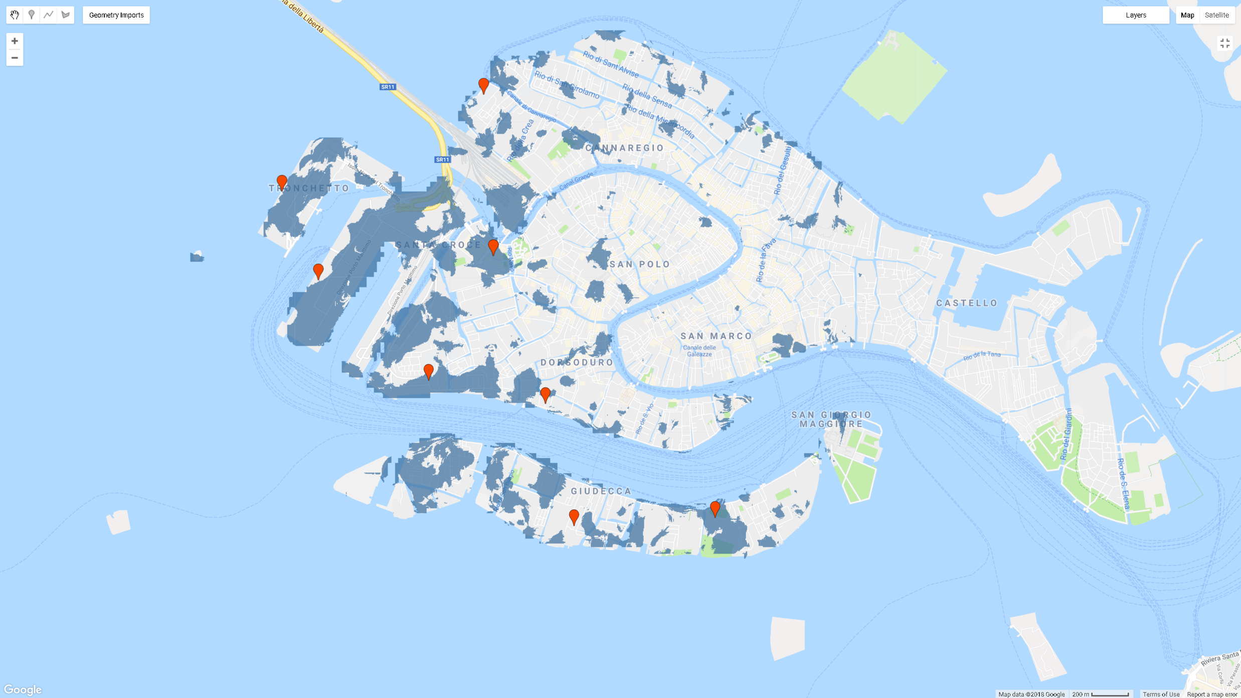
Published:
Identify species of a tree using an image of its leaf. Model powered by deep learning and hosted as a chatbot. 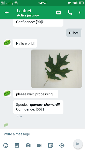
Published:
A simulator which allocates stormwater-associated costs based on user inputs for several different rate structures and incentives. 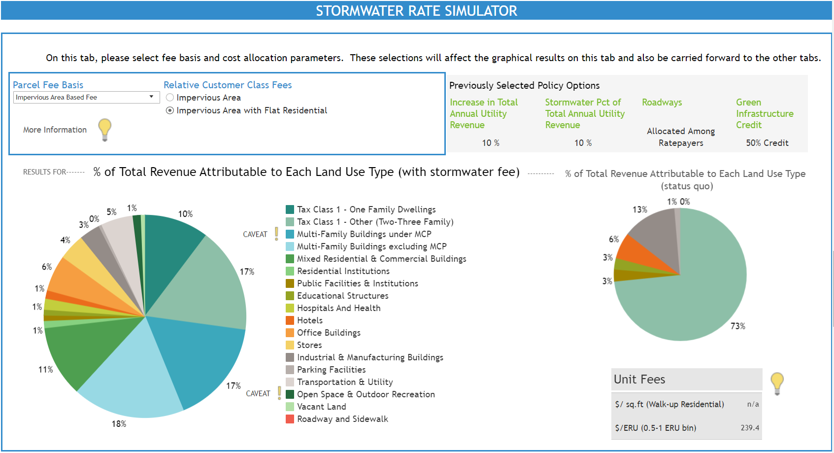
Published:
A deep learning system saving you from falling into the trap of wildfire risk and social inequality 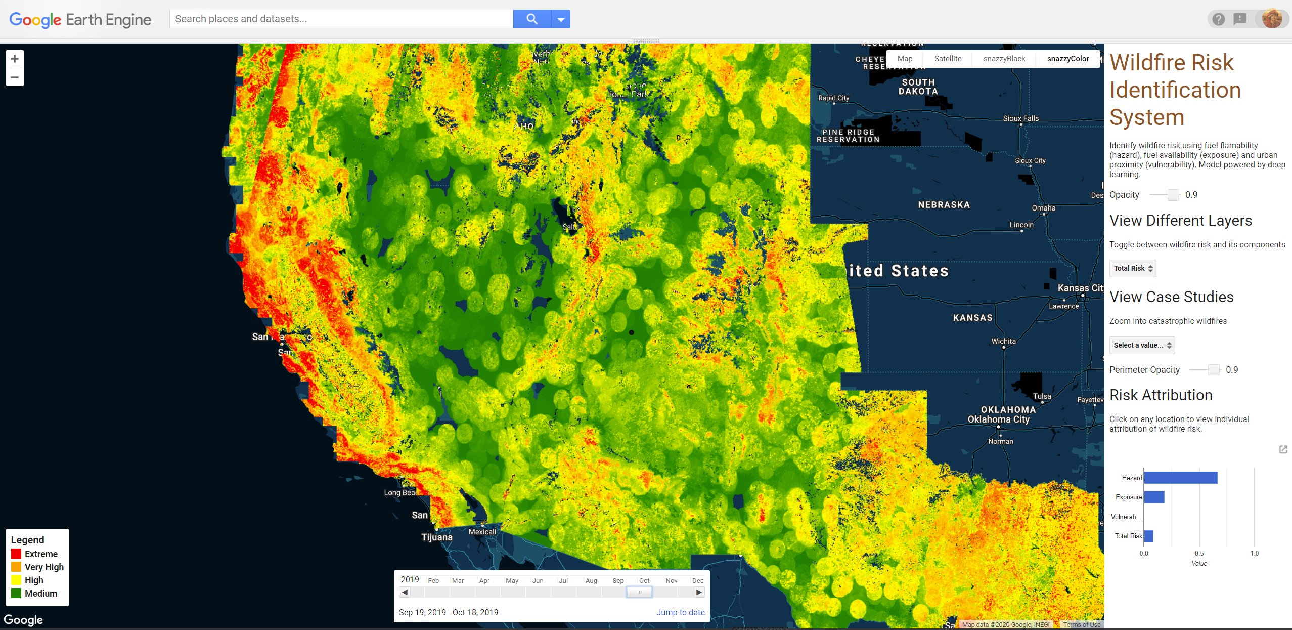
Published:
DamageMap is a system composed of rapid buildings damage assessment and a convenient user interface for result visualization. 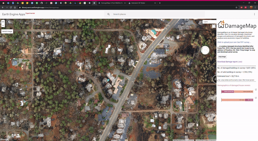
Published:
AIRGAP: Assessing Inequality in Risk from Global Air Pollution tool allows for the exploration and analysis of near-real time air quality and income inequality around the world based on sattelite data. 
Published in Remote Sensing of Environment, 2019
This paper is about developing a scalable plant drought stress indicator using vegetation optical depth.
Recommended citation: Rao, K., Anderegg, W.R.L., Sala, A., Martínez-Vilalta, J. & Konings, A.G. (2019). Satellite-based vegetation optical depth as an indicator of drought-driven tree mortality. Remote Sens. Environ., 227, 125–136. https://www.sciencedirect.com/science/article/pii/S0034425719301208
Published in New Phytologist, 2019
This paper presents a short review for the use of microwave remote sensing of plant water.
Recommended citation: Konings, A.G., Rao, K. & Steele‐Dunne, S.C. (2019). Macro to Micro: Microwave Remote Sensing of Plant Water Content for Physiology and Ecology. New Phytol., nph.15808. https://nph.onlinelibrary.wiley.com/doi/full/10.1111/nph.15808
Published in Remote Sensing of Environment, 2020
This paper presents a deep learning-based solution to rapidly estimate forest dryness across western USA.
Recommended citation: Rao, K., Williams, A.P., Fortin, J. & Konings, A.G. (2020). SAR-enhanced mapping of live fuel moisture content. Remote Sens. Environ., 245. https://www.sciencedirect.com/science/article/pii/S003442572030167X
Published in AGU Advances, 2021
This paper presents a novel convolutional neural network to detect canals and study the effect of canals on land subsidence.
Recommended citation: Dadap, N. C., Hoyt, A. M., Cobb, A. R., Oner, D., Kozinski, M., Fua, P. V., Rao, K., Harvey, C. F., & Konings, A. G. (2021). Drainage Canals in Southeast Asian Peatlands Increase Carbon Emissions. AGU Advances, 2(1), e2020AV000321. https://doi.org/10.1029/2020AV000321 https://agupubs.onlinelibrary.wiley.com/doi/full/10.1029/2020AV000321
Published in Geophysical Research Letters, 2021
This paper re-examines the commonly held assumption that VOD interannual variations are proportional to interannual variations in biomass, and shows that the assumption for the most part, is invalid.
Recommended citation: Konings, A. G., Holtzman, N. M., Rao, K., Xu, L., & Saatchi, S. S. (2021). Interannual Variations of Vegetation Optical Depth are Due to Both Water Stress and Biomass Changes. Geophysical Research Letters, 48(16), e2021GL095267. https://doi.org/10.1029/2021gl095267 https://agupubs.onlinelibrary.wiley.com/doi/abs/10.1029/2021GL095267
Published in International Journal of Disaster Risk Reduction, 2021
This paper presents an AI-based method to classify damaged buildings using post-wildfire images only.
Recommended citation: Galanis, M., Rao, K., Yao, X., Tsai, Y.-L., Ventura, J., & Fricker, G. A. (2021). DamageMap: A post-wildfire damaged buildings classifier. International Journal of Disaster Risk Reduction, 102540. https://doi.org/10.1016/j.ijdrr.2021.102540 https://www.sciencedirect.com/science/article/pii/S221242092100501X
Published in Nature Ecology & Evolution, 2022
We show that an ecosystem’s sensitivity to drought affects fire hazard.
Recommended citation: Rao, K., Williams, A.P., Diffenbaugh N.S., Yebra, M., & Konings, A.G. (2022). Plant-water sensitivity regulates wildfire vulnerability. Nature Ecology & Evolution, 6, 332–339 (2022) https://www.nature.com/articles/s41559-021-01654-2
Published in IGARSS 2022 - 2022 IEEE International Geoscience and Remote Sensing Symposium, 2022
A new ground-based radar system to monitor vegetatation water at plot-scales
Recommended citation: Rao, K., Ulloa, Y. J., Bienert, N., Chiariello, N. R., Holtzman, N. M., Quetin, G. R., et al. (2022). Side-Facing UHF-Band Radar System to Monitor Tree Water Status. In International Geoscience and Remote Sensing Symposium (IGARSS) (Vol. 2022-July, pp. 5559–5562). Institute of Electrical and Electronics Engineers Inc. https://doi.org/10.1109/IGARSS46834.2022.9883620 https://ieeexplore.ieee.org/abstract/document/9883620
Published in Geophysical Research Letters, 2023
Mimicking a randomized control trial of wildfires, scientists use satellites to uncover the key role of vegetation dryness in wildfire risk, aiding wildfire management and preparedness in California.
Recommended citation: Rao, K., Williams, A.P., Diffenbaugh, N.S., Yebra, M., Bryant, C. and Konings, A.G., 2023. Dry Live Fuels Increase the Likelihood of Lightning‐Caused Fires. Geophysical Research Letters, 50(15), p.e2022GL100975. https://agupubs.onlinelibrary.wiley.com/doi/10.1029/2022GL100975
Published in Global Change Biology, 2024
We seek to understand the relative importance of the dominant species for regional-scale variations in woody plant responses to water stress.
Recommended citation: Konings, A. G., Rao, K., McCormick, E. L., Trugman, A. T., Williams, A. P., Diffenbaugh, N. S., Yebra, M., & Zhao, M. (2024). Tree species explain only half of explained spatial variability in plant water sensitivity. Global Change Biology, 30, e17425. https://onlinelibrary.wiley.com/doi/full/10.1111/gcb.17425
Published in Tackling Climate Change with Machine Learning Workshop, NeurIPS 2024, 2024
The first public benchmark for classifying corporate spend line items into emissions factors — the dominant method companies use to estimate scope 3 carbon emissions. Enables systematic evaluation of LLMs for automated carbon accounting.
Recommended citation: Dumit, A., Rao, K., Kwee, T., Glidden, J., Gopalakrishnan, V., Tsai, K., & Suh, S. (2024). ATLAS: A spend classification benchmark for estimating scope 3 carbon emissions. Tackling Climate Change with Machine Learning Workshop at NeurIPS 2024. https://www.climatechange.ai/papers/neurips2024/70
Published in Tackling Climate Change with Machine Learning Workshop, NeurIPS 2024, 2024
A multi-agent LLM system, paired with retrieval-augmented generation, that extracts, classifies, and validates concrete carbon reduction actions from public sustainability reports — building a sector- and region-specific library of reduction levers.
Recommended citation: Gopalakrishnan, V., Ulissi, S., Dumit, A., Rao, K., Tsai, K., & Suh, S. (2024). How are companies reducing emissions? An LLM-based approach to creating a carbon emissions reduction levers library at scale. Tackling Climate Change with Machine Learning Workshop at NeurIPS 2024. https://www.climatechange.ai/papers/neurips2024/90
Published in arXiv preprint, 2025
Proposes evaluation criteria for AI-assisted carbon footprinting systems, arguing that credibility should be established through system-level evaluations — benchmark performance, data quality, uncertainty, and transparent documentation — rather than line-item review.
Recommended citation: Ulissi, S., Dumit, A., Joyce, P. J., Rao, K., Watson, S., & Suh, S. (2025). Criteria for Credible AI-assisted Carbon Footprinting Systems: The Cases of Mapping and Lifecycle Modeling. arXiv:2509.00240. https://arxiv.org/abs/2509.00240
Published:
This talk presented retrofitting measures for the storwater drainage system of the IIT Madras campus. The 650-acre campus’ stormwater drainage network is more than 50 years old fails frequently during big storms. The talk focussed on presenting a 3-phase expansion plan to include-
Published:
Published:
Published:
Watch the panel discussion on helping prospective international students below.
Published:
Published: