
DamageMap: A post-wildfire damaged buildings classifier
Published in International Journal of Disaster Risk Reduction, 2021
Recommended citation: Galanis, M., Rao, K., Yao, X., Tsai, Y.-L., Ventura, J., & Fricker, G. A. (2021). DamageMap: A post-wildfire damaged buildings classifier. International Journal of Disaster Risk Reduction, 102540. https://doi.org/10.1016/j.ijdrr.2021.102540 https://www.sciencedirect.com/science/article/pii/S221242092100501X
The increasing frequency and severity of wildfire events in the last few decades have created an urgent need for new technologies that allow rapid surveying and assessment of post-wildfire building damage. However, existing technologies lack in accuracy and ability to scale to effectively aid disaster relief and recovery. Even today, most wildfire event inspectors need to physically visit the areas impacted by wildfires and manually classify building damage, requiring considerable time and resources. Here, we present DamageMap, an artificial intelligence-powered post-wildfire building damage classifier. DamageMap is a binary classifier (outputs are –“damaged” or “undamaged”). Unlike existing solutions that require both pre- and post-wildfire imagery to classify building damage, DamageMap relies on post-wildfire images alone by separating the segmentation and classification tasks. Our model has an overall accuracy of 98% on the validation set (five wildfire events all around the world) and 92% and 98% on two independent test sets from the Camp Fire and the Carr Fire, respectively. Excellent model performance across a variety of datasets provides evidence of DamageMap’s robustness to unseen data. Thus, DamageMap may help governmental and non-governmental agencies rapidly survey building damage using post-wildfire aerial or satellite imagery in wildfire-impacted areas. DamageMap is available as a server-side web-application.
DamageMap predictions on test set.
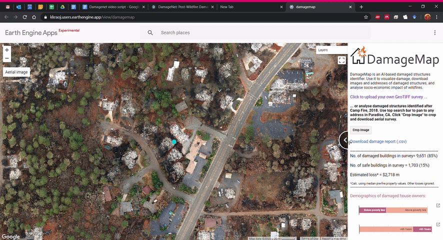
Check out DamageMap on an interactive app here.
DamageMap in the news:
- AI system developed by Stanford researchers identifies buildings damaged by wildfire, Stanford News
- DamageMap Uses AI to Spot Damage from Wildfires, Tech Briefs
- New computer program rapidly detects homes, buildings damaged by wildfires, Monterey Herald
- AI system to help identify buildings damaged by wildfire, India AI
- New computer program quickly detects homes and buildings damaged by California wildfires, The Most
- New computer program rapidly detects homes, buildings damaged by California wildfires, Times Herald
- AI Tool Uses Aerial Imaging to Scan Structures for Wildfire Damage, Photonics
- AI Model Rapidly Identifies Structures Damaged by Wildfires, NVIDIA Developer Blog