Publications

Maps showing forest dryness in western USA 
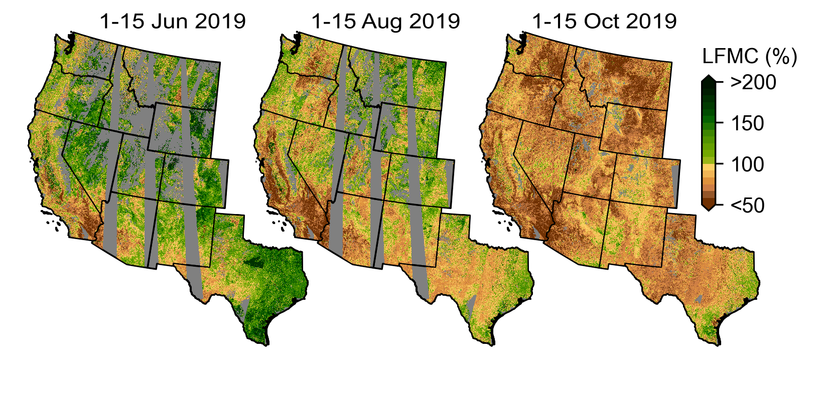
Predicted vegetation wetness over western US using remote sensing and deep learning.

You can also find my publications on my Google Scholar profile.

Criteria for Credible AI-assisted Carbon Footprinting Systems: The Cases of Mapping and Lifecycle Modeling

Published in arXiv preprint, 2025

Proposes evaluation criteria for AI-assisted carbon footprinting systems, arguing that credibility should be established through system-level evaluations — benchmark performance, data quality, uncertainty, and transparent documentation — rather than line-item review.

Recommended citation: Ulissi, S., Dumit, A., Joyce, P. J., Rao, K., Watson, S., & Suh, S. (2025). Criteria for Credible AI-assisted Carbon Footprinting Systems: The Cases of Mapping and Lifecycle Modeling. arXiv:2509.00240. https://arxiv.org/abs/2509.00240

How are companies reducing emissions? An LLM-based approach to creating a carbon emissions reduction levers library at scale

Published in Tackling Climate Change with Machine Learning Workshop, NeurIPS 2024, 2024

A multi-agent LLM system, paired with retrieval-augmented generation, that extracts, classifies, and validates concrete carbon reduction actions from public sustainability reports — building a sector- and region-specific library of reduction levers.

Recommended citation: Gopalakrishnan, V., Ulissi, S., Dumit, A., Rao, K., Tsai, K., & Suh, S. (2024). How are companies reducing emissions? An LLM-based approach to creating a carbon emissions reduction levers library at scale. Tackling Climate Change with Machine Learning Workshop at NeurIPS 2024. https://www.climatechange.ai/papers/neurips2024/90

ATLAS: A spend classification benchmark for estimating scope 3 carbon emissions

Published in Tackling Climate Change with Machine Learning Workshop, NeurIPS 2024, 2024

The first public benchmark for classifying corporate spend line items into emissions factors — the dominant method companies use to estimate scope 3 carbon emissions. Enables systematic evaluation of LLMs for automated carbon accounting.

Recommended citation: Dumit, A., Rao, K., Kwee, T., Glidden, J., Gopalakrishnan, V., Tsai, K., & Suh, S. (2024). ATLAS: A spend classification benchmark for estimating scope 3 carbon emissions. Tackling Climate Change with Machine Learning Workshop at NeurIPS 2024. https://www.climatechange.ai/papers/neurips2024/70

Tree species explain only half of explained spatial variability in plant water sensitivity

Published in Global Change Biology, 2024

We seek to understand the relative importance of the dominant species for regional-scale variations in woody plant responses to water stress.

Recommended citation: Konings, A. G., Rao, K., McCormick, E. L., Trugman, A. T., Williams, A. P., Diffenbaugh, N. S., Yebra, M., & Zhao, M. (2024). Tree species explain only half of explained spatial variability in plant water sensitivity. Global Change Biology, 30, e17425. https://onlinelibrary.wiley.com/doi/full/10.1111/gcb.17425

Dry Live Fuels Increase the Likelihood of Lightning‐Caused Fires

Published in Geophysical Research Letters, 2023

Mimicking a randomized control trial of wildfires, scientists use satellites to uncover the key role of vegetation dryness in wildfire risk, aiding wildfire management and preparedness in California.

Recommended citation: Rao, K., Williams, A.P., Diffenbaugh, N.S., Yebra, M., Bryant, C. and Konings, A.G., 2023. Dry Live Fuels Increase the Likelihood of Lightning‐Caused Fires. Geophysical Research Letters, 50(15), p.e2022GL100975. https://agupubs.onlinelibrary.wiley.com/doi/10.1029/2022GL100975

Side-Facing UHF-Band Radar System to Monitor Tree Water Status

Published in IGARSS 2022 - 2022 IEEE International Geoscience and Remote Sensing Symposium, 2022

A new ground-based radar system to monitor vegetatation water at plot-scales

Recommended citation: Rao, K., Ulloa, Y. J., Bienert, N., Chiariello, N. R., Holtzman, N. M., Quetin, G. R., et al. (2022). Side-Facing UHF-Band Radar System to Monitor Tree Water Status. In International Geoscience and Remote Sensing Symposium (IGARSS) (Vol. 2022-July, pp. 5559–5562). Institute of Electrical and Electronics Engineers Inc. https://doi.org/10.1109/IGARSS46834.2022.9883620 https://ieeexplore.ieee.org/abstract/document/9883620

DamageMap: A post-wildfire damaged buildings classifier

Published in International Journal of Disaster Risk Reduction, 2021

This paper presents an AI-based method to classify damaged buildings using post-wildfire images only.

Recommended citation: Galanis, M., Rao, K., Yao, X., Tsai, Y.-L., Ventura, J., & Fricker, G. A. (2021). DamageMap: A post-wildfire damaged buildings classifier. International Journal of Disaster Risk Reduction, 102540. https://doi.org/10.1016/j.ijdrr.2021.102540 https://www.sciencedirect.com/science/article/pii/S221242092100501X

Interannual Variations of Vegetation Optical Depth Are Due to Both Water Stress and Biomass Changes

Published in Geophysical Research Letters, 2021

This paper re-examines the commonly held assumption that VOD interannual variations are proportional to interannual variations in biomass, and shows that the assumption for the most part, is invalid.

Recommended citation: Konings, A. G., Holtzman, N. M., Rao, K., Xu, L., & Saatchi, S. S. (2021). Interannual Variations of Vegetation Optical Depth are Due to Both Water Stress and Biomass Changes. Geophysical Research Letters, 48(16), e2021GL095267. https://doi.org/10.1029/2021gl095267 https://agupubs.onlinelibrary.wiley.com/doi/abs/10.1029/2021GL095267

Drainage canals in Southeast Asian peatlands increase carbon emissions

Published in AGU Advances, 2021

This paper presents a novel convolutional neural network to detect canals and study the effect of canals on land subsidence.

Recommended citation: Dadap, N. C., Hoyt, A. M., Cobb, A. R., Oner, D., Kozinski, M., Fua, P. V., Rao, K., Harvey, C. F., & Konings, A. G. (2021). Drainage Canals in Southeast Asian Peatlands Increase Carbon Emissions. AGU Advances, 2(1), e2020AV000321. https://doi.org/10.1029/2020AV000321 https://agupubs.onlinelibrary.wiley.com/doi/full/10.1029/2020AV000321

Satellite-based vegetation optical depth as an indicator of drought-driven tree mortality

Published in Remote Sensing of Environment, 2019

This paper is about developing a scalable plant drought stress indicator using vegetation optical depth.

Recommended citation: Rao, K., Anderegg, W.R.L., Sala, A., Martínez-Vilalta, J. & Konings, A.G. (2019). Satellite-based vegetation optical depth as an indicator of drought-driven tree mortality. Remote Sens. Environ., 227, 125–136. https://www.sciencedirect.com/science/article/pii/S0034425719301208


Research graciously funded by

NASA logo
UPS logo
Amazon AWS logo
Shell logo
Stanford School of Earth logo
Stanford Data Science Institute logo
Stanford Woods Institute for the Environment logo